Landscapes Portal Logo
  • Register
  • Sign in
  • Help
  • Feedback
  • Home
  • About
  • Layers
    • Explore Layers
    • Upload Layer
  • Maps
  • Tools
  • Projects
    • Projects
    • Articles
  • Blog
  • Resources
    • Documents
    • Groups
    • Search
  • Advance Search

Blog

  • Home
  • Blog
  • 2014
  • August
  • 05
  • Explore data from our network of LDSF sites in the Sentinel Landscapes

You are using an outdated browser that is not supported by GeoNode.

Please use a modern browser like Mozilla Firefox, Google Chrome or Safari.

×

Placeholder for status-message

Placeholder for status-message-body

Explore data from our network of LDSF sites in the Sentinel Landscapes

Written by Tor-G. Vagen on Aug. 5, 2014 in Biodiversity, Land Degradation, Deforestation, Soil Mapping.

Last update on Aug. 5, 2014.

Explore data from our network of LDSF sites in the Sentinel Landscapes

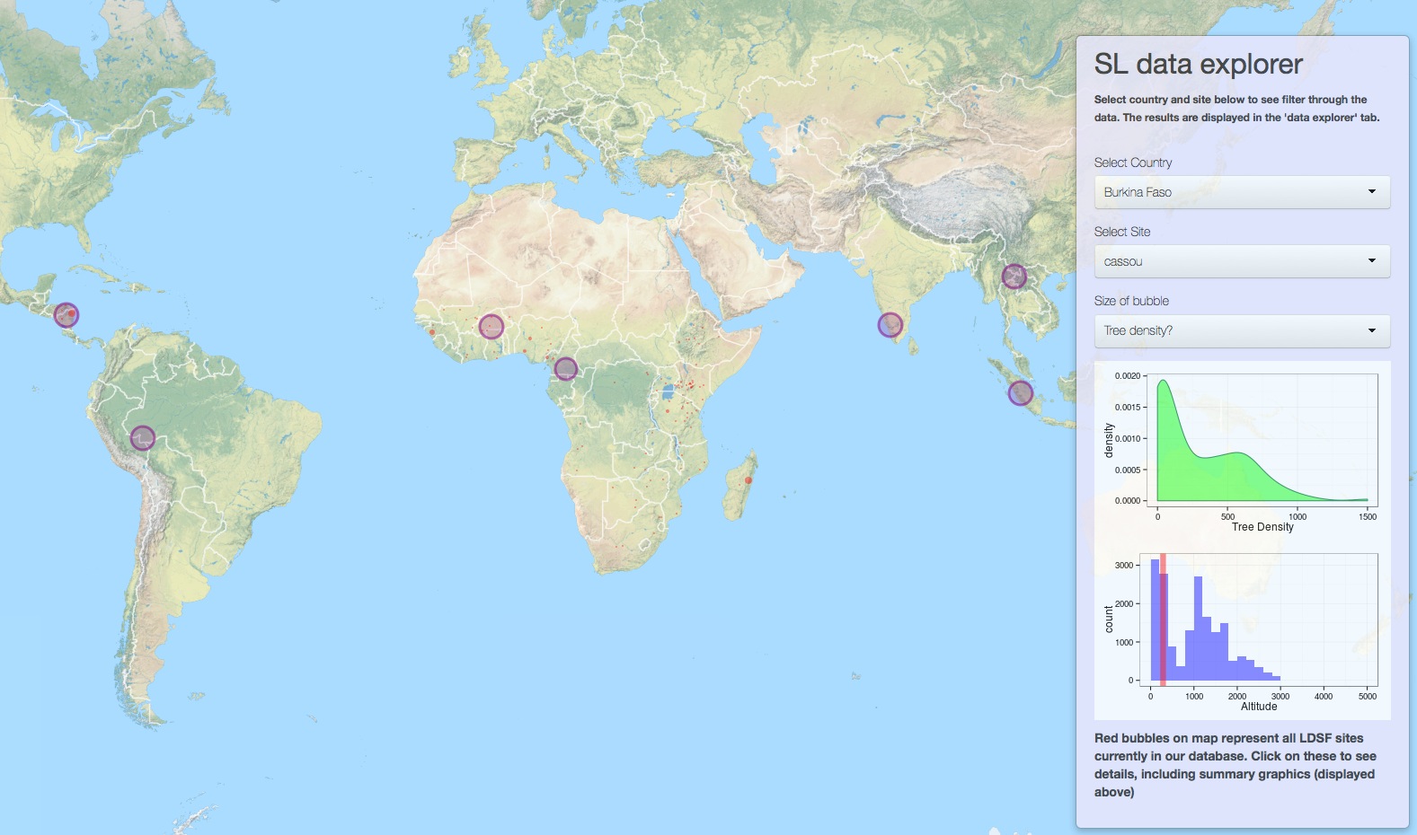
We are in the process of developing an interactive online mapping and analytical platform, and have just released a test version for the Sentinel Landscapes initiative. Click here to run the application in a new window in your browser. You can also view the sites on the Landscapes Portal here.

Tags : landscapes sentinel

Short url : http://landscapeportal.org/blog/17/

Discussions : Comments are closed.

Next entry

Landscape portal data status

Previous entry

Usage statistics for the Landscapes Portal

Related entries

  • The Land Degradation Surveillance Framework (LDSF)
  • Field sampling on Mt Elgon, Uganda
  • Landscapeportal Workshop @ ICRAF
  • About the Landscape Portal
  • The Western Ghats sentinel landscape

Similar entries

  • Working with nature: tropical forest regrowth and its potential for mitigating climate change
  • Building forest-water knowledge and capacity for Forest and Landscape Restoration in Ethiopia
  • R seminar series: Seminar 9
  • The Western Ghats sentinel landscape
  • Farmer-managed natural regeneration as a land restoration strategy. Under what conditions does it work?

Pingbacks

Pingbacks are closed.

Comments

Comments are closed.

Welcome

The Landscapes Portal blog is where you can share ideas and experiences on landscape level applications of GeoScience, as well as modeling and mapping in general.


Please do not hesitate to send us suggestions and/or requests for functionality also.

Recent Entries

  • Farmer-managed natural regeneration as a land restoration strategy. Under what conditions does it work?
  • Regreening Africa App and Data Reporting System (DRS) Trainings
  • Data visualization with ggplot2 for intermediate and advanced users
  • Introduction to data visualization with ggplot2
  • Data manipulation in R

Categories

  • Biodiversity 10 entries
  • Deforestation 6 entries
  • GIS 5 entries
  • Land Degradation 10 entries
  • New maps 4 entries
  • R 23 entries
  • Software 11 entries
  • Soil Mapping 7 entries
  • Training 16 entries
  • Workshop 7 entries

Authors

  • s.palmas 1 entry
  • tor2 1 entry
  • eopiyo 5 entries
  • PMakui 1 entry
  • faith 5 entries
  • Leigh Winowiecki 1 entry
  • JWanjara 2 entries
  • admin 15 entries
  • aida.bargues.tobella 2 entries
  • jaysnm 1 entry
  • muhammad 4 entries
  • madelonlohbeck 3 entries
  • Tor-G. Vagen 26 entries

Tags

  • Aerial
  • Africa
  • Android
  • capacity building
  • data analysis
  • Data Manipulation
  • DRS
  • FLR
  • gdal
  • ggplot
  • ggplot2
  • gis
  • ICRAF_useR
  • images
  • land
  • landscapeportal
  • Landscapes
  • LDSF
  • Machine Learning
  • monitoring
  • Portal
  • Project
  • R
  • Regreening
  • Reproducibility
  • resoration
  • restoration
  • R programming
  • software
  • soil infiltration capacity
  • statistics
  • training
  • water
  • workshop

Recent Comments

  • No comments yet.

Random Entries

  • R seminar series - part 6
  • Data manipulation in R
  • R seminar series - part 7
  • Explore data from our network of LDSF sites in the Sentinel Landscapes
  • ICRAF GeoScience Lab launches new Android App - Africa Tree Finder

Popular Entries

  • No entries yet.

Archives

  • 2014
    • January
      • January 16
      • January 24
    • February
      • February 10
      • February 25
      • February 26
    • March
      • March 7
      • March 13
    • April
      • April 2
    • May
      • May 8
      • May 21
    • June
      • June 4
    • August
      • August 5
      • August 21
    • October
      • October 14
    • November
      • November 5
  • 2015
    • January
      • January 29
    • February
      • February 11
      • February 22
    • March
      • March 6
      • March 12
      • March 19
      • March 25
      • March 27
    • April
      • April 8
      • April 30
    • July
      • July 24
    • October
      • October 13
  • 2017
    • March
      • March 30
    • April
      • April 27
    • September
      • September 6
    • November
      • November 7
  • 2018
    • January
      • January 15
    • July
      • July 18
  • 2019
    • February
      • February 10
    • October
      • October 15
      • October 25
    • November
      • November 11
      • November 21
  • 2020
    • January
      • January 15
      • January 20
    • February
      • February 10
    • August
      • August 13
    • September
      • September 17

2022 © World Agroforestry Centre | Powered by GeoNode version 2.4.1 | Help | About

Sign in