
Sudan Climate Resilience
- Scientist: Tor Vagen
- July 14, 2021, 4:47 a.m.
- Donor :
- Grant Ref :
- Members :
Sudan Climate Resilience project data portal.
Sudan Climate Resilience project data portal.
Project layers, maps and documents
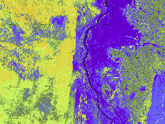
Sudan - Soil erosion, 2019-2020
- July 27, 2021, 9:04 a.m.
Map showing predicted erosion (%) for six states in Sudan based on the Land Degradation Surveillance Framework (LDSF) data and predictive models. Selected references: Vågen, T.-G., Winowiecki, L. A., Neely, C., Chesterman, S., & Bourne, M. (2018). Spatial assessments of soil organic carbon for stakeholder decision-making – a case study from Kenya. SOIL, 4(4), 259–266. https://doi.org/10.5194/soil-4-259-2018 Vågen, T.-G. T.-G., & Winowiecki, L. A. (2013). Mapping of soil organic carbon stocks for spatially explicit assessments of climate change mitigation potential. Environmental Research Letters, 8(1), 015011. https://doi.org/10.1088/1748-9326/8/1/015011 Winowiecki, L., Vågen, T.-G., & Huising, J. (2016). Effects of land cover on ecosystem services in Tanzania: A spatial assessment of soil organic carbon. Geoderma, 263, 274–283. https://doi.org/10.1016/j.geoderma.2015.03.010 Vågen, T.-G., Winowiecki, L. A., Abegaz, A., & Hadgu, K. M. (2013). Landsat-based approaches for mapping of land degradation prevalence and soil functional properties in Ethiopia. Remote Sensing of Environment, 134, 266–275.
Sudan - Soil pH, 2019-2020
- July 27, 2021, 9:38 a.m.
DOWNLOAD LAYER HERE [ http://landscapeportal.org/uploaded/layers/sudan_ph_lc8_2019_2020_30m.tiff ] Map showing predicted soil pH for six states in Sudan based on the Land Degradation Surveillance Framework (LDSF) data and predictive models. Selected references: Vågen, T.-G., Winowiecki, L. A., Neely, C., Chesterman, S., & Bourne, M. (2018). Spatial assessments of soil organic carbon for stakeholder decision-making – a case study from Kenya. SOIL, 4(4), 259–266. https://doi.org/10.5194/soil-4-259-2018 Vågen, T.-G. T.-G., & Winowiecki, L. A. (2013). Mapping of soil organic carbon stocks for spatially explicit assessments of climate change mitigation potential. Environmental Research Letters, 8(1), 015011. https://doi.org/10.1088/1748-9326/8/1/015011 Winowiecki, L., Vågen, T.-G., & Huising, J. (2016). Effects of land cover on ecosystem services in Tanzania: A spatial assessment of soil organic carbon. Geoderma, 263, 274–283. https://doi.org/10.1016/j.geoderma.2015.03.010 Vågen, T.-G., Winowiecki, L. A., Abegaz, A., & Hadgu, K. M. (2013). Landsat-based approaches for mapping of land degradation prevalence and soil functional properties in Ethiopia. Remote Sensing of Environment, 134, 266–275.
Sudan - Soil Organic Carbon (SOC), 2019-2020
- July 27, 2021, 7:59 a.m.
Map showing predicted SOC for six states in Sudan based on the Land Degradation Surveillance Framework (LDSF) data and predictive models. Selected references: Vågen, T.-G., Winowiecki, L. A., Neely, C., Chesterman, S., & Bourne, M. (2018). Spatial assessments of soil organic carbon for stakeholder decision-making – a case study from Kenya. SOIL, 4(4), 259–266. https://doi.org/10.5194/soil-4-259-2018 Vågen, T.-G. T.-G., & Winowiecki, L. A. (2013). Mapping of soil organic carbon stocks for spatially explicit assessments of climate change mitigation potential. Environmental Research Letters, 8(1), 015011. https://doi.org/10.1088/1748-9326/8/1/015011 Winowiecki, L., Vågen, T.-G., & Huising, J. (2016). Effects of land cover on ecosystem services in Tanzania: A spatial assessment of soil organic carbon. Geoderma, 263, 274–283. https://doi.org/10.1016/j.geoderma.2015.03.010 Vågen, T.-G., Winowiecki, L. A., Abegaz, A., & Hadgu, K. M. (2013). Landsat-based approaches for mapping of land degradation prevalence and soil functional properties in Ethiopia. Remote Sensing of Environment, 134, 266–275. https://doi.org/10.1016/j.rse.2013.03.006
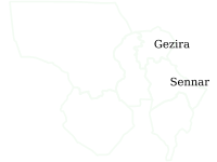
Soil and land health maps 2019/2020, Sudan (North Kordufan, South Kordufan, Gezira, White Nile, Sennar, Blue Nile)
- July 27, 2021, 8:57 a.m.
Maps of soil and land health across six states in Sudan (North Kordufan, South Kordufan, Gezira, White Nile, Sennar, Blue Nile)
Recent Posts
We work towards the application of GeoScience in real decision contexts, such as climate change adaptation, hydrological effects of changes in climate and land cover, targeting of agroforestry interventions, provision of soil fertility and surveillance advisory services for smallholder farmers, digital soil and land use/cover mapping, and measuring impacts of interventions, all using open source software.